
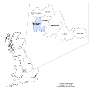
The Dudley Borough
Dudley is a metropolitan borough formed in 1974. It is located on the edge of the West Midlands conurbation, approximately 9 miles west of the city of Birmingham and 6 miles south of Wolverhampton. Rural Staffordshire and Worcestershire border Dudley Borough to the west and south.
Being at the heart of the Black Country, which also includes the neighbouring boroughs of Sandwell and Walsall and the city of Wolverhampton, Dudley has a rich cultural and industrial heritage. The Borough is predominantly urban in character, but rather than having one primary centre there are four main towns interspersed with smaller towns and urban villages. This has given rise to a very local feel that is a feature of the Borough’s communities.
The main town centres are: Dudley towards the north of the Borough, Stourbridge in the southwest, Halesowen in the southeast and Brierley Hill near the centre. The nationally renowned Merry Hill Shopping Centre and the Waterfront business and leisure complex now form part of Brierley Hill town centre.
Dudley Borough In Brief (click each section to explore)
The latest population estimates from 2021, published by the Office for National Statistics, show that Dudley Borough has a population of around 323,600. The population has seen sustained growth in recent years, with approximately 18,500 more people in the borough now compared to the estimate in 2001. Dudley is the fifth largest local authority district in the West Midlands Region based on population. 17.6% of the population are aged under 15 and 20.5% are 65 and over.
Population projections based on the 2018 estimates - the latest projections available - predict that the population of Dudley Borough will increase to 350,100 by 2040, an increase of 8.2% from the 2021 figure. Those aged 40 to 50 and over 65 are expected to undergo the largest increase in numbers over the time period.
According to the Census 2021 82.4% of the borough population are White British. Dudley has become more ethnically diverse since 2011 when this figure was 88.5%. Asian groups constitute 8.4% of the population, with the largest individual groups in the borough being Pakistani (4.6%) and Indian (12.4%). 2.8% of people are from mixed ethnic groups, 2.5% Black ethnic groups and a further 2.5% from White groups other than British.
The latest figure for life expectancy at birth for men in Dudley Borough is 78.8 years, just over half a year less than the England figure of 79.4 years. For women life expectancy is 82.2 years, around one year lower than the national figure of 83.1 (2018-20 three-year average). Census 2021 shows that 79.3% of the borough population consider themselves to be in ‘Good’ or ‘Very Good’ health. The corresponding figures for males and females are 80.4% and 78.2% respectively.
As of July 2023, there were 9,165 people in Dudley Borough claiming benefit principally due to unemployment, which constitutes 4.7% of the population aged 16 to 64. The equivalent figure for England is 3.8%. 7.4% of those aged 18 to 24 living in Dudley Borough are claiming, notably higher the proportion for England of 4.9%.
According to data from 2021 Dudley Borough has 12,100 households with at least one person aged 16 to 64 where no-one aged 16 or over is in employment. This equates to 13.3% of households, very similar to the 13.4% for England. These people may be unemployed but looking for work, or unavailable to work because of family commitments, retirement, study, sickness or disability.
In the year to March 2023 the employment rate of residents in Dudley Borough was 76.5%, the highest of the four Black Country local authorities. This is the proportion of people in paid work, on government-supported training or employment programmes and those doing unpaid family work as a proportion of those aged 16 to 64. The figure for England was 75.7%.
The latest earnings figures from 2022 show the median pay of full-time workers living in Dudley Borough is £30,417 per year, below the England figure of £33,208 but more than Sandwell (£27,471), Walsall (£28,373) and Wolverhampton (£29,855). Earnings for men living in Dudley Borough are £32,549 and for women are £26,262.
There were 141,101 residential dwellings in the borough as of August 2023. Of the 137,069 occupied households at the time of the Census 2021, 66.4% were owned outright or with a mortgage, 15.4% were rented from the council, 12.1% privately rented and 3.5% rented from other social landlords. Almost half (48.4%) of accommodation was semi-detached, with 21.6% detached, 15.4% terraced and 12% flats.
Across the year ending December 2022 the average house price for all dwellings sold and registered in Dudley Borough was £234,810. This is the highest figure amongst the four Black Country local authorities, but significantly lower than the £373,287 average for England. Comparing the borough’s house prices with earnings gives an indication of relative affordability. Figures from 2022 show that in Dudley Borough the median house price was 6.8 times the median full-time annual earnings of residents. The ratio in Sandwell is also 6.8, with Walsall lower at 6.6 and Wolverhampton the lowest of the Black Country local authorities at 6.2; the figure for England is 8.3.
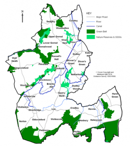
The borough covers 38 square miles / 98 square kilometres. Though predominantly an urban area, 18% is designated as green belt and 14% categorised as publicly accessible open spaces. There are ten Sites of Special Scientific Interest, of national importance for their geology and/or biodiversity, two National Nature Reserves and seven Local Nature Reserves, plus the river Stour and 15 miles of canal network. The borough has 22 Conservation Areas, which are areas of special architectural or historic interest and are a particularly important part of the borough's heritage. There are around 300 Statutory Listed Buildings in the borough which are considered of national importance so are given special protection against inappropriate alteration or demolition. In addition, just under 300 buildings of historic or architectural significance are on Dudley's "Local List" and are considered worthy of protection and conservation for their contribution to local character and distinctiveness.
... more on Dudley's historic environment
The borough has an extensive transport infrastructure with 647 miles / 1,041 kilometres of roads and access to the motorway network near Dudley and Halesowen. A train line links Stourbridge to Birmingham, and a new 11km Metro line is under construction that in phase one will link Dudley and phase two Brierley Hill with the wider West Midlands Metro and facilitate easy access to the national rail network. Preparatory works for the new Metro line began on Castle Hill in Dudley in February 2020, with plans for up to 14 stops. Passenger services between Wednesbury and Dudley are expected to start in 2024, with funding solutions currently being sought for the line extension to Brierley Hill to allow construction at the earliest opportunity. 63.9% of borough residents in employment travel to work by car, 5.6% walk, 4.2% take a bus and 1.4% a train or tram. 21.7% work mainly from home (Census 2021)*.
* Census 2021 took place during a national lockdown due to the COVID-19 Pandemic. The government advice at the time was for people to work from home (if they could) and avoid public transport, which will have impacted the responses to the census question on method of travel to work.
Dudley Borough is ranked as the 104th most deprived of the 317 local authority districts in England (where 1 is most deprived), ranking it as less deprived than five of the other six districts in the West Midlands conurbation. While this suggests Dudley has relatively low deprivation for an urban area, it masks the disparity in levels of deprivation across the borough. The latest national Index of Multiple Deprivation from 2019 showed that 28.1% of the Dudley Borough population live in areas in the 20% most deprived in England. These are principally found in a zone covering Dudley, Pensnett, Netherton and Brierley Hill, but also include parts of Coseley, Lye, Halesowen and Stourbridge.